Geolocate

Nagpur topographic map

Click on the map to display elevation.

About this map

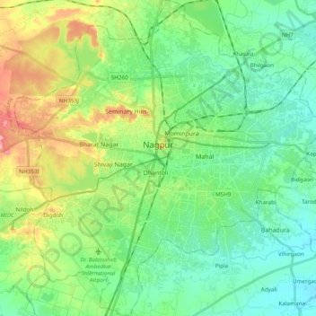
Name: Nagpur topographic map, elevation, terrain.

Location: Nagpur, Nagpur Urban Taluka, Nagpur, Maharashtra, India (21.05297 78.99522 21.23100 79.17885)

Average elevation: 309 m

Minimum elevation: 274 m

Maximum elevation: 389 m

Other topographic maps

Click on a map to view its topography, its elevation and its terrain.

Digdoh

India > Maharashtra > Nagpur Urban Taluka > Nagpur

Average elevation: 326 m

Gear up for your next adventure:

🧣Evaporative Cooling Towel - Beat the heat during intense summer climbs
🧦Thermal Socks - Warm socks for winter hiking or camping
🕶️Polarized Sunglasses - Protect your eyes with durable polarized lenses
Bushcraft Tarp - Versatile emergency shelter or gear protection
🧥Waterproof Pants - Keep dry during rainy hiking conditions

As an Amazon Associate, this site earns from qualifying purchases at no extra cost to you.