Geolocate

Appalachia topographic map

Click on the map to display elevation.

About this map
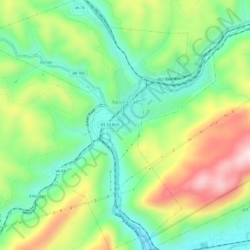
Name: Appalachia topographic map, elevation, terrain.

Location: Appalachia, Wise County, Virginia, 24216, United States (36.87721 -82.81340 36.92129 -82.76525)

Average elevation: 618 m

Minimum elevation: 449 m

Maximum elevation: 893 m

Other topographic maps

Click on a map to view its topography, its elevation and its terrain.

Almira

United States > Virginia > Wise County > Pound

Average elevation: 588 m

Carfax

United States > Virginia > Wise County

Average elevation: 557 m

Gilley

United States > Virginia > Wise County

Average elevation: 582 m

Stonega

United States > Virginia > Wise County

Average elevation: 685 m

Gear up for your next adventure:

🧴Waterproofing Spray - Restore the DWR coating on jackets and tents
🦟Insect Repellent - Keep mosquitoes and black flies away in wooded areas
🔥Camping Stove - Portable stoves to cook outdoors with ease
❄️Traction Ice Cleats - Slip-on spikes for icy trails and winter hiking
🧦Hiking Socks - Moisture-wicking and comfortable socks for long hikes

As an Amazon Associate, this site earns from qualifying purchases at no extra cost to you.