Geolocate

Pruna topographic map

Click on the map to display elevation.

About this map

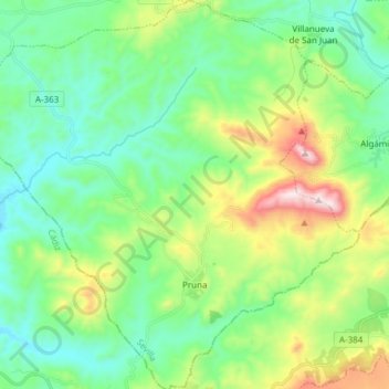
Name: Pruna topographic map, elevation, terrain.

Location: Pruna, Sevilla, Andalusia, Spain (36.93991 -5.30257 37.06074 -5.15753)

Average elevation: 525 m

Minimum elevation: 297 m

Maximum elevation: 1,117 m

Other topographic maps

Click on a map to view its topography, its elevation and its terrain.

Cortijo la Reina

Spain > Andalusia > Córdoba

Average elevation: 106 m

Gear up for your next adventure:

🧥Ultralight Puffy Jacket - Maximum warmth that packs down to the size of an orange
🔋Lithium AA Batteries - Long-lasting power that performs in extreme cold
💧Hydration Bladder - Hands-free hydration solution for long treks
🧥Waterproof Pants - Keep dry during rainy hiking conditions
🧥Thermal Fleece Jacket - Versatile insulation for changing mountain temperatures

As an Amazon Associate, this site earns from qualifying purchases at no extra cost to you.