
Make a donation
Gear up for your next adventure:
As an Amazon Associate, this site earns from qualifying purchases at no extra cost to you.
Catanzaro topographic map
Click on the map to display elevation.
Make a donation
Gear up for your next adventure:
As an Amazon Associate, this site earns from qualifying purchases at no extra cost to you.
Catanzaro
Catanzaro overlooks the Gulf of Squillace, in the Ionian Sea. The district of Catanzaro stretches from the sea to an elevation of 600 metres (2,000 ft). The historic center is approximately 300 metres (980 ft) above sea level. The town dates back to the valley of Fiumarella (formerly known as River Zaro). The Bishopric, St. Tryphon (or San Rocco) and St. John (or castle) marks the city's historical centre and is connected to the North Sila. Due to its particular geography, the municipality gets wet from the sea and is still subjected to a snowy winter. Catanzaro's rivers include the mainstream of the Fiumarella (in local dialect Hjiumareddha), which joins with the river Musofalo, and the torrent Corach (formerly called Crotalo).
Make a donation
Gear up for your next adventure:
As an Amazon Associate, this site earns from qualifying purchases at no extra cost to you.
About this map
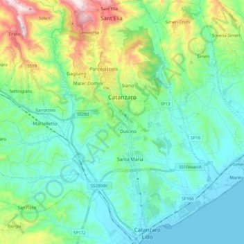
Name: Catanzaro topographic map, elevation, terrain.
Location: Catanzaro, Calabria, Italy (38.81484 16.53903 38.96858 16.68686)
Average elevation: 195 m
Minimum elevation: 0 m
Maximum elevation: 847 m
Make a donation
Gear up for your next adventure:
As an Amazon Associate, this site earns from qualifying purchases at no extra cost to you.