Spokane Valley topographic map
Interactive map
Click on the map to display elevation.
About this map
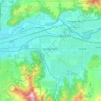
Name: Spokane Valley topographic map, elevation, terrain.
Location: Spokane Valley, Spokane County, Washington, United States (47.59981 -117.34699 47.70988 -117.14277)
Average elevation: 673 m
Minimum elevation: 573 m
Maximum elevation: 1,116 m
Other topographic maps
Click on a map to view its topography, its elevation and its terrain.
Spokane
United States > Washington > Spokane County
Spokane, Spokane County, Washington, United States
Average elevation: 655 m
Liberty Lake
United States > Washington > Spokane County
Liberty Lake, Spokane County, Washington, United States
Average elevation: 644 m
Peone
United States > Washington > Spokane County
Peone, Spokane County, Washington, United States
Average elevation: 630 m
Mount Spokane
United States > Washington > Spokane County
Mount Spokane, Spokane County, Washington, United States
Average elevation: 1,475 m
Hampton Bay
United States > Washington > Spokane County
Hampton Bay, Spokane County, Washington, United States
Average elevation: 666 m
Nine Mile Falls
United States > Washington > Spokane County
Nine Mile Falls, Spokane County, Washington, 99026, United States
Average elevation: 536 m
Mica Peak
United States > Washington > Spokane County
Mica Peak, Spokane County, Washington, United States
Average elevation: 1,311 m
Otis Orchards-East Farms
United States > Washington > Spokane County
Otis Orchards-East Farms, Spokane County, Washington, United States
Average elevation: 668 m
Mount Spokane State Park
United States > Washington > Spokane County
Mount Spokane State Park, Spokane County, Washington, United States
Average elevation: 976 m
Mead
United States > Washington > Spokane County
Mead, Spokane County, Washington, 99021, United States
Average elevation: 585 m
Country Homes
United States > Washington > Spokane County
Country Homes, Spokane County, Washington, 99251, United States
Average elevation: 599 m
Mica
United States > Washington > Spokane County
Mica, Spokane County, Washington, 99023, United States
Average elevation: 772 m
East Spokane
United States > Washington > Spokane County > Spokane Valley > East Spokane
East Spokane, Spokane Valley, Spokane County, Washington, 99260, United States
Average elevation: 625 m
Riverfront Park
United States > Washington > Spokane County > Spokane
Riverfront Park, Spokane, Spokane County, Washington, United States
Average elevation: 583 m
Beacon Hill
United States > Washington > Spokane County
Beacon Hill, Spokane County, Washington, 99211, United States
Average elevation: 659 m
Cheney
United States > Washington > Spokane County
Cheney, Spokane County, Washington, United States
Average elevation: 725 m
Orchard Prairie
United States > Washington > Spokane County
Orchard Prairie, Spokane County, Washington, United States
Average elevation: 682 m