Geolocate

Athlone topographic map

Click on the map to display elevation.

About this map

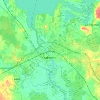
Name: Athlone topographic map, elevation, terrain.

Location: Athlone, County Westmeath, Leinster, Ireland (53.40664 -8.01690 53.45088 -7.88754)

Average elevation: 43 m

Minimum elevation: 28 m

Maximum elevation: 81 m

Other topographic maps

Click on a map to view its topography, its elevation and its terrain.

Bunbrosna

Ireland > County Westmeath

Average elevation: 97 m

Mullingar

Ireland > County Westmeath > Mullingar

Average elevation: 101 m

Gear up for your next adventure:

🥽Outdoor Goggles - Protective eyewear for outdoor activities
🧥Waterproof Pants - Keep dry during rainy hiking conditions
🕶️Polarized Sunglasses - Reduces glare from snow and water at high elevations
🥫Freeze-Dried Meals - Lightweight, high-calorie nutrition for multi-day treks
🛶Canoe Life Vest - Safety vest for water sports

As an Amazon Associate, this site earns from qualifying purchases at no extra cost to you.