Geolocate

Batac topographic map

Click on the map to display elevation.

About this map

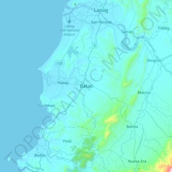
Name: Batac topographic map, elevation, terrain.

Location: Batac, Ilocos Norte, Ilocos Region, 2906, Philippines (17.89550 120.40452 18.21550 120.72452)

Average elevation: 53 m

Minimum elevation: -1 m

Maximum elevation: 1,265 m

Other topographic maps

Click on a map to view its topography, its elevation and its terrain.

MMSU Technology Park

Philippines > Ilocos Norte > Batac

Average elevation: 19 m

Gear up for your next adventure:

🧰Emergency Multi-Tool - Compact multi-tool for outdoor survival
🚑Survival Whistle - Signal for help across long distances in mountains
🔭Outdoor Binoculars - Lightweight binoculars for birdwatching and hiking
🥾Mountain Hiking Shoes - Shoes with superior grip for mountainous terrain
🧴Outdoor Sunscreen - High SPF protection for high-altitude UV exposure

As an Amazon Associate, this site earns from qualifying purchases at no extra cost to you.