
Thank you for supporting this site ❤️
Make a donation
Make a donation
Gear up for your next adventure:
As an Amazon Associate, this site earns from qualifying purchases at no extra cost to you.
Casteldimezzo topographic map
Click on the map to display elevation.
Thank you for supporting this site ❤️
Make a donation
Make a donation
Gear up for your next adventure:
As an Amazon Associate, this site earns from qualifying purchases at no extra cost to you.
About this map
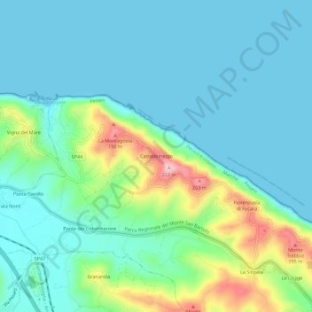
Name: Casteldimezzo topographic map, elevation, terrain.
Location: Casteldimezzo, Pesaro, Pesaro e Urbino, 61012, Italy (43.93755 12.78581 43.97755 12.82581)
Average elevation: 47 m
Minimum elevation: 0 m
Maximum elevation: 215 m
Thank you for supporting this site ❤️
Make a donation
Make a donation
Gear up for your next adventure:
As an Amazon Associate, this site earns from qualifying purchases at no extra cost to you.