Geolocate

Leuven topographic map

Click on the map to display elevation.

About this map
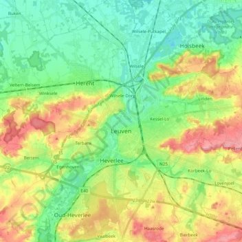
Name: Leuven topographic map, elevation, terrain.

Location: Leuven, Flemish Brabant, Flanders, Belgium (50.82421 4.64030 50.94407 4.77053)

Average elevation: 43 m

Minimum elevation: 4 m

Maximum elevation: 107 m

Other topographic maps

Click on a map to view its topography, its elevation and its terrain.
Leuven

Belgium > Flemish Brabant > Leuven > Leuven

Average elevation: 50 m

Bos

Belgium > Flemish Brabant > Leuven > Zoutleeuw

Average elevation: 31 m

Orsmaal

Belgium > Flemish Brabant > Leuven

Average elevation: 44 m

Optielt

Belgium > Flemish Brabant > Leuven > Tielt

Average elevation: 51 m

Butsel

Belgium > Flemish Brabant > Leuven > Boutersem

Average elevation: 66 m

Beneden-Kessel

Belgium > Flemish Brabant > Leuven > Leuven > Kessel-Lo

Average elevation: 34 m

Ourodenberg

Belgium > Flemish Brabant > Leuven > Aarschot

Average elevation: 16 m

Stadspark

Belgium > Flemish Brabant > Leuven > Aarschot

Average elevation: 24 m

Gear up for your next adventure:

🧭GPS Outdoor Watch - Smart watch for navigation and fitness tracking in nature
🩹Moleskin Blister Pads - Direct protection for painful foot pressure points
🔥Camping Stove - Portable stoves to cook outdoors with ease
⛺Lightweight Backpacking Tent - Compact tent for efficient hiking trips
🧢Sun Protection Cap - Breathable cap to protect from sun exposure

As an Amazon Associate, this site earns from qualifying purchases at no extra cost to you.