Geolocate

Giza topographic map

Click on the map to display elevation.

About this map
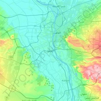
Name: Giza topographic map, elevation, terrain.

Location: Giza, Aj Jiza, 12524, Egypt (29.82708 31.05181 30.14708 31.37181)

Average elevation: 72 m

Minimum elevation: 6 m

Maximum elevation: 330 m

Other topographic maps

Click on a map to view its topography, its elevation and its terrain.

Geziret el Dahab

Egypt > Aj Jiza > Giza

Average elevation: 23 m

Nazlet Al Siman and Al Sisi

Egypt > Aj Jiza > Giza

Average elevation: 42 m

Al Ayat City

Egypt > Aj Jiza

Average elevation: 23 m

Memphis

Egypt > Aj Jiza > Mit Rahinah

Average elevation: 23 m

Gear up for your next adventure:

🥾All-Terrain Hiking Boots - Versatile boots for varied hiking conditions
🥾Mountain Hiking Boots - High-traction boots for rocky terrain
🧢Beanie Hat - Keep your head warm in cold weather
🧣Merino Neck Gaiter - Protects against wind, sun, and cold at high altitudes
🥾Light Hiking Boots - Lightweight and comfortable boots for day hikes

As an Amazon Associate, this site earns from qualifying purchases at no extra cost to you.