Geolocate

Silverdale topographic map

Click on the map to display elevation.

About this map

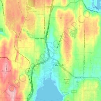
Name: Silverdale topographic map, elevation, terrain.

Location: Silverdale, Kitsap County, Washington, United States (47.63342 -122.72481 47.70607 -122.63939)

Average elevation: 73 m

Minimum elevation: 0 m

Maximum elevation: 166 m

Gear up for your next adventure:

🧭GPS Outdoor Watch - Smart watch for navigation and fitness tracking in nature
🧥Thermal Layer - Insulating layer for cold outdoor conditions
🥤Collapsible Travel Cup - Saves space and weight in your mess kit
🛌Down Sleeping Bag - Superior warmth-to-weight ratio for cold nights
🔥Emergency Fire Starter - Reliable ignition source for all weather conditions

As an Amazon Associate, this site earns from qualifying purchases at no extra cost to you.