
Thank you for supporting this site ❤️
Make a donation
Make a donation
Gear up for your next adventure:
As an Amazon Associate, this site earns from qualifying purchases at no extra cost to you.
古界 topographic map
Click on the map to display elevation.
Thank you for supporting this site ❤️
Make a donation
Make a donation
Gear up for your next adventure:
As an Amazon Associate, this site earns from qualifying purchases at no extra cost to you.
About this map
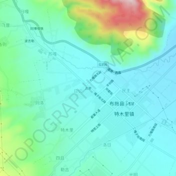
Name: 古界 topographic map, elevation, terrain.
Location: 古界, 日切村, 布拖县, 凉山彝族自治州, 四川省, 616300, 中国 (27.69571 102.78046 27.73571 102.82046)
Average elevation: 2,443 m
Minimum elevation: 2,367 m
Maximum elevation: 2,724 m
Thank you for supporting this site ❤️
Make a donation
Make a donation
Gear up for your next adventure:
As an Amazon Associate, this site earns from qualifying purchases at no extra cost to you.