
Thank you for supporting this site ❤️
Make a donation
Make a donation
Gear up for your next adventure:
As an Amazon Associate, this site earns from qualifying purchases at no extra cost to you.
Mekla topographic map
Click on the map to display elevation.
Thank you for supporting this site ❤️
Make a donation
Make a donation
Gear up for your next adventure:
As an Amazon Associate, this site earns from qualifying purchases at no extra cost to you.
About this map
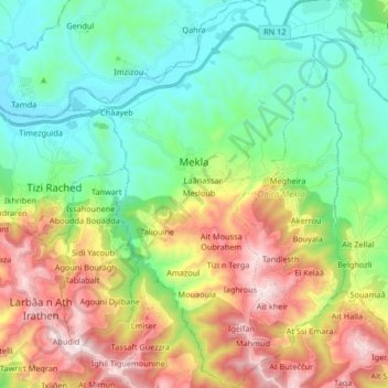
Name: Mekla topographic map, elevation, terrain.
Location: Mekla, Mekla District, Tizi Ouzou, Algeria (36.61026 4.21373 36.74285 4.31973)
Average elevation: 417 m
Minimum elevation: 83 m
Maximum elevation: 1,040 m
Thank you for supporting this site ❤️
Make a donation
Make a donation
Gear up for your next adventure:
As an Amazon Associate, this site earns from qualifying purchases at no extra cost to you.
Other topographic maps
Click on a map to view its topography, its elevation and its terrain.
Agouni Bouafir
Algeria > Tizi Ouzou > Mekla District > Mekla > Agouni Bouafir
Average elevation: 465 m