Geolocate

Viladrau topographic map

Click on the map to display elevation.

About this map

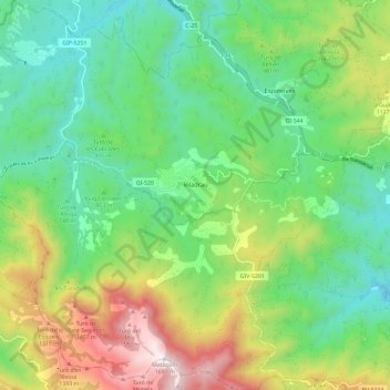
Name: Viladrau topographic map, elevation, terrain.

Location: Viladrau, Osona, Girona, Catalonia, 17406, Spain (41.80155 2.32350 41.88913 2.42462)

Average elevation: 914 m

Minimum elevation: 533 m

Maximum elevation: 1,686 m

Other topographic maps

Click on a map to view its topography, its elevation and its terrain.

Pla de la Calma

Spain > Catalonia > Osona > el Brull

Average elevation: 1,111 m

Gear up for your next adventure:

🦶Hiking Shoe Insoles - Added support for high arches and long days on feet
🔥Emergency Fire Starter - Reliable ignition source for all weather conditions
🧢Beanie Hat - Keep your head warm in cold weather
🧦Outdoor Socks - Durable socks designed for hiking and outdoor sports
🧢Hiking Hat - Sun-protective and breathable hats for long treks

As an Amazon Associate, this site earns from qualifying purchases at no extra cost to you.