Geolocate

Waldkirchen topographic map

Click on the map to display elevation.

About this map

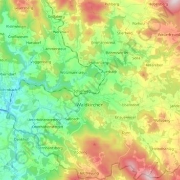
Name: Waldkirchen topographic map, elevation, terrain.

Location: Waldkirchen, Landkreis Freyung-Grafenau, Bavaria, 94065, Germany (48.68205 13.54335 48.79631 13.67472)

Average elevation: 599 m

Minimum elevation: 386 m

Maximum elevation: 963 m

Other topographic maps

Click on a map to view its topography, its elevation and its terrain.

Gear up for your next adventure:

🧭GPS Tracker - Track your location in remote areas safely
📷Outdoor Action Camera - Capture high-elevation views and rugged adventures
🦟Insect Repellent - Keep mosquitoes and black flies away in wooded areas
🧥Packable Rain Jacket - Breathable waterproof layer for unpredictable weather
🧭GPS Outdoor Watch - Smart watch for navigation and fitness tracking in nature

As an Amazon Associate, this site earns from qualifying purchases at no extra cost to you.