
Thank you for supporting this site ❤️
Make a donation
Make a donation
Gear up for your next adventure:
As an Amazon Associate, this site earns from qualifying purchases at no extra cost to you.
Ambabaquí topographic map
Click on the map to display elevation.
Thank you for supporting this site ❤️
Make a donation
Make a donation
Gear up for your next adventure:
As an Amazon Associate, this site earns from qualifying purchases at no extra cost to you.
About this map
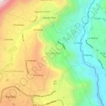
Name: Ambabaquí topographic map, elevation, terrain.
Location: Ambabaquí, Pelileo, Tungurahua, 180701, Ecuador (-1.33296 -78.54973 -1.29296 -78.50973)
Average elevation: 2,383 m
Minimum elevation: 2,010 m
Maximum elevation: 2,901 m
Thank you for supporting this site ❤️
Make a donation
Make a donation
Gear up for your next adventure:
As an Amazon Associate, this site earns from qualifying purchases at no extra cost to you.