Geolocate

Zikhron Yaakov topographic map

Click on the map to display elevation.

About this map

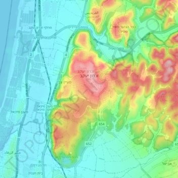
Name: Zikhron Yaakov topographic map, elevation, terrain.

Location: Zikhron Yaakov, Hadera Subdistrict, Haifa District, Israel (32.52622 34.92781 32.60411 35.00306)

Average elevation: 53 m

Minimum elevation: -1 m

Maximum elevation: 177 m

Other topographic maps

Click on a map to view its topography, its elevation and its terrain.

Tirat Karmel

Israel > Haifa District

Average elevation: 76 m

Gear up for your next adventure:

🥾Mountain Hiking Boots - High-traction boots for rocky terrain
🎒Backpack Rain Cover - External shield to keep your entire pack dry
🥾Trail Running Boots - Durable shoes designed for trail running
🦶Anti-Blister Balm - Prevents friction and hotspots during long ascents
🔦LED Flashlight - Powerful and long-lasting flashlight for camping and emergencies

As an Amazon Associate, this site earns from qualifying purchases at no extra cost to you.