
Make a donation
Gear up for your next adventure:
As an Amazon Associate, this site earns from qualifying purchases at no extra cost to you.
Fusagasugá ciudad topographic map
Click on the map to display elevation.
Make a donation
Gear up for your next adventure:
As an Amazon Associate, this site earns from qualifying purchases at no extra cost to you.
Fusagasugá ciudad
It was founded in 1592 by Spanish priests. The town located some 56 kilometers from the capital, Bogotá; borders Pasca, Arbeláez, Tibacuy, Silvania and other municipalities of Sumapaz. Its elevation is 5,669 feet (1,728 m) above sea level, and the average temperature 20 °C (68 °F).
Make a donation
Gear up for your next adventure:
As an Amazon Associate, this site earns from qualifying purchases at no extra cost to you.
About this map
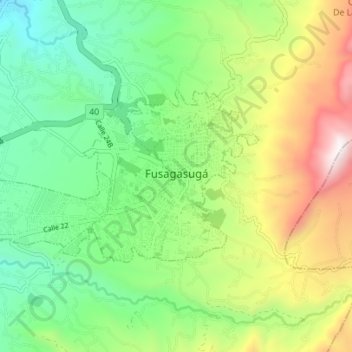
Name: Fusagasugá ciudad topographic map, elevation, terrain.
Average elevation: 1,802 m
Minimum elevation: 1,314 m
Maximum elevation: 2,619 m
Make a donation
Gear up for your next adventure:
As an Amazon Associate, this site earns from qualifying purchases at no extra cost to you.