
Algeciras topographic map
Click on the map to display elevation.
About this map
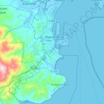
Name: Algeciras topographic map, elevation, terrain.
Location: Algeciras, Campo de Gibraltar, Cádiz, Andalusia, Spain (36.05020 -5.55110 36.17549 -5.42230)
Average elevation: 77 m
Minimum elevation: -7 m
Maximum elevation: 767 m
Other topographic maps
Click on a map to view its topography, its elevation and its terrain.
Castillo de Castellar
Spain > Andalusia > Campo de Gibraltar > Castellar de la Frontera > Castellar Viejo de la Frontera
Average elevation: 102 m