Geolocate

Zhob topographic map

Click on the map to display elevation.

Zhob

Zhob has a semi-arid climate (Köppen BSh). Its rainfall is high enough to avoid the arid climate category found at lower elevations. Zhob receive rainfall on occasions from the monsoon, though this occurs very erratically.

Wikipedia (CC-BY-SA 3.0)

About this map

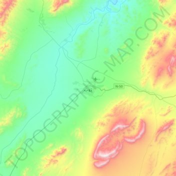
Name: Zhob topographic map, elevation, terrain.

Location: Zhob, Zhob Tehsil, Zhob District, Zhob Division, Balochistan, 85200, Pakistan (31.17971 69.28770 31.49971 69.60770)

Average elevation: 1,569 m

Minimum elevation: 1,258 m

Maximum elevation: 2,351 m

Other topographic maps

Click on a map to view its topography, its elevation and its terrain.

Gear up for your next adventure:

🛶Canoe Life Vest - Safety vest for water sports
🥾Hiking Leggings - Comfortable leggings for outdoor activities
🥾Lightweight Hiking Boots - Boots for comfort and mobility on long hikes
🧢Beanie Hat - Keep your head warm in cold weather
🩹Moleskin Blister Pads - Direct protection for painful foot pressure points

As an Amazon Associate, this site earns from qualifying purchases at no extra cost to you.