
Make a donation
Gear up for your next adventure:
As an Amazon Associate, this site earns from qualifying purchases at no extra cost to you.
Dimitsana topographic map
Click on the map to display elevation.
Make a donation
Gear up for your next adventure:
As an Amazon Associate, this site earns from qualifying purchases at no extra cost to you.
Dimitsana
Dimitsana is built on a mountain slope at an elevation of 950 meters. From its southern side a marvelous view of Megalopolis plain and Taygetus is provided. Dimitsana is located 53 km east of Pyrgos, 31 km northwest of Tripoli, 23 km northwest of Megalopoli and 17 km northeast of Andritsaina. The village has a school, a historical library, several churches, a post office, an open-air water-power museum, an open amphitheater, hotels and a square.
Make a donation
Gear up for your next adventure:
As an Amazon Associate, this site earns from qualifying purchases at no extra cost to you.
About this map
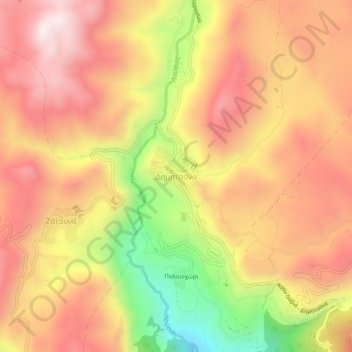
Name: Dimitsana topographic map, elevation, terrain.
Average elevation: 1,025 m
Minimum elevation: 553 m
Maximum elevation: 1,335 m
Make a donation
Gear up for your next adventure:
As an Amazon Associate, this site earns from qualifying purchases at no extra cost to you.