Geolocate

Yakutat topographic map

Click on the map to display elevation.

About this map

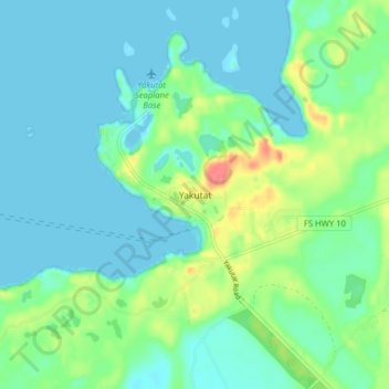
Name: Yakutat topographic map, elevation, terrain.

Location: Yakutat, Alaska, United States (59.53200 -139.75257 59.57200 -139.71257)

Average elevation: 14 m

Minimum elevation: -8 m

Maximum elevation: 56 m

Gear up for your next adventure:

🩹Moleskin Blister Pads - Direct protection for painful foot pressure points
🛰️Satellite Messenger - Emergency communication for areas with no cell service
👟Trail Running Shoes - Agile footwear for fast-paced topographic exploration
🔭Compact Monocular - One-handed bird watching and trail spotting
🛶Kayak Dry Bag - Waterproof storage for kayaking adventures

As an Amazon Associate, this site earns from qualifying purchases at no extra cost to you.