
Make a donation
Gear up for your next adventure:
As an Amazon Associate, this site earns from qualifying purchases at no extra cost to you.
Santo Domingo topographic map
Click on the map to display elevation.
Make a donation
Gear up for your next adventure:
As an Amazon Associate, this site earns from qualifying purchases at no extra cost to you.
About this map
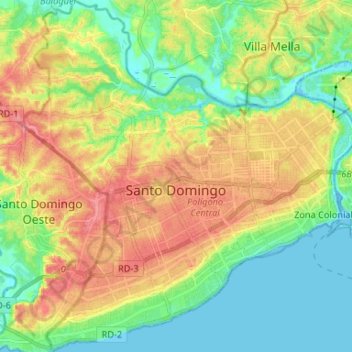
Name: Santo Domingo topographic map, elevation, terrain.
Location: Santo Domingo, Distrito Nacional, 03201, Dominican Republic (18.42266 -69.99928 18.54759 -69.87451)
Average elevation: 30 m
Minimum elevation: -3 m
Maximum elevation: 70 m
Make a donation
Gear up for your next adventure:
As an Amazon Associate, this site earns from qualifying purchases at no extra cost to you.
Other topographic maps
Click on a map to view its topography, its elevation and its terrain.
Santo Domingo
Dominican Republic > Distrito Nacional > Santo Domingo de Guzmán
Average elevation: 29 m
Santo Domingo
Dominican Republic > Distrito Nacional > Santo Domingo de Guzmán
Average elevation: 18 m
Santo Domingo
Dominican Republic > Distrito Nacional > Santo Domingo de Guzmán
Average elevation: 18 m