
Make a donation
Gear up for your next adventure:
As an Amazon Associate, this site earns from qualifying purchases at no extra cost to you.
Geldern topographic map
Click on the map to display elevation.
Make a donation
Gear up for your next adventure:
As an Amazon Associate, this site earns from qualifying purchases at no extra cost to you.
Geldern
Geldern lies in the plains of the lower, northern Rhineland, west of the Rhine. Its average elevation is 27 m AMSL. The river Niers, a tributary of the Meuse (Maas), flows through Geldern. The stream Gelderner Fleuth flows into the Niers in Geldern.
Make a donation
Gear up for your next adventure:
As an Amazon Associate, this site earns from qualifying purchases at no extra cost to you.
About this map
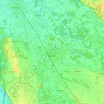
Name: Geldern topographic map, elevation, terrain.
Location: Geldern, Kreis Kleve, North Rhine-Westphalia, 47608, Germany (51.46713 6.20062 51.57657 6.42059)
Average elevation: 28 m
Minimum elevation: 16 m
Maximum elevation: 54 m
Make a donation
Gear up for your next adventure:
As an Amazon Associate, this site earns from qualifying purchases at no extra cost to you.
Other topographic maps
Click on a map to view its topography, its elevation and its terrain.
Make a donation
Gear up for your next adventure:
As an Amazon Associate, this site earns from qualifying purchases at no extra cost to you.
An der Manier
Germany > North Rhine-Westphalia > Kreis Kleve > Kalkar > Neulouisendorf
Average elevation: 30 m
Make a donation
Gear up for your next adventure:
As an Amazon Associate, this site earns from qualifying purchases at no extra cost to you.