Geolocate

Currimao topographic map

Click on the map to display elevation.

About this map

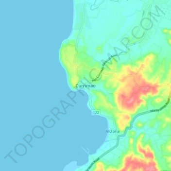
Name: Currimao topographic map, elevation, terrain.

Location: Currimao, Ilocos Norte, Ilocos Region, 2903, Philippines (17.97945 120.44683 18.05945 120.52683)

Average elevation: 13 m

Minimum elevation: -1 m

Maximum elevation: 80 m

Gear up for your next adventure:

🧣Evaporative Cooling Towel - Beat the heat during intense summer climbs
🧣Merino Neck Gaiter - Protects against wind, sun, and cold at high altitudes
👟Sport Hiking Sandals - Breathable footwear for water crossings and camp rest
🔥Emergency Fire Starter - Reliable ignition source for all weather conditions
🧤Rechargeable Heated Gloves - Extreme warmth for Canadian winter expeditions

As an Amazon Associate, this site earns from qualifying purchases at no extra cost to you.