Geolocate

Dengkil topographic map

Click on the map to display elevation.

About this map

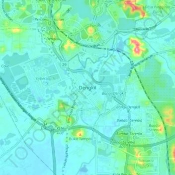
Name: Dengkil topographic map, elevation, terrain.

Location: Dengkil, Sepang, 43800, Malaysia (2.82802 101.63563 2.90802 101.71563)

Average elevation: 18 m

Minimum elevation: -2 m

Maximum elevation: 120 m

Gear up for your next adventure:

🥾Lightweight Hiking Shoes - Comfortable shoes for day hikes
🦶Anti-Blister Balm - Prevents friction and hotspots during long ascents
💧Collapsible Water Bottle - Space-saving water bottle for outdoor activities
🚲Handlebar Phone Mount - View topographic-map.com live while cycling
🧥Softshell Jacket - Windproof and breathable jacket for hiking

As an Amazon Associate, this site earns from qualifying purchases at no extra cost to you.