
Thank you for supporting this site ❤️
Make a donation
Make a donation
Gear up for your next adventure:
As an Amazon Associate, this site earns from qualifying purchases at no extra cost to you.
Ammanford topographic map
Click on the map to display elevation.
Thank you for supporting this site ❤️
Make a donation
Make a donation
Gear up for your next adventure:
As an Amazon Associate, this site earns from qualifying purchases at no extra cost to you.
About this map
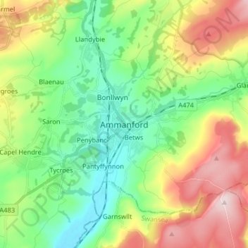
Name: Ammanford topographic map, elevation, terrain.
Location: Ammanford, Carmarthenshire, Wales, SA18 3DL, United Kingdom (51.75263 -4.02877 51.83263 -3.94877)
Average elevation: 142 m
Minimum elevation: 10 m
Maximum elevation: 374 m
Thank you for supporting this site ❤️
Make a donation
Make a donation
Gear up for your next adventure:
As an Amazon Associate, this site earns from qualifying purchases at no extra cost to you.