Geolocate

Sandy topographic map

Click on the map to display elevation.

About this map

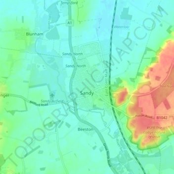
Name: Sandy topographic map, elevation, terrain.

Location: Sandy, Central Bedfordshire, England, United Kingdom (52.10880 -0.31714 52.15364 -0.23644)

Average elevation: 30 m

Minimum elevation: 16 m

Maximum elevation: 73 m

Other topographic maps

Click on a map to view its topography, its elevation and its terrain.

Gear up for your next adventure:

🦌Outdoor Trail Camera - Monitor wildlife activity near your favorite spots
🧰Emergency Multi-Tool - Compact multi-tool for outdoor survival
🎒Hiking Daypack - Lightweight and durable backpacks for day trips and excursions
💡LED Camping Lantern - Illuminate your campsite with long-lasting lanterns
🧴Outdoor Sunscreen - High SPF protection for high-altitude UV exposure

As an Amazon Associate, this site earns from qualifying purchases at no extra cost to you.