
Sandridge topographic map
Click on the map to display elevation.
About this map
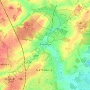
Name: Sandridge topographic map, elevation, terrain.
Location: Sandridge, St Albans, Hertfordshire, England, United Kingdom (51.75716 -0.33751 51.80346 -0.26699)
Average elevation: 105 m
Minimum elevation: 73 m
Maximum elevation: 134 m
Other topographic maps
Click on a map to view its topography, its elevation and its terrain.
Tyttenhanger
United Kingdom > England > Hertfordshire > St Albans > Colney Heath
Average elevation: 83 m