
Make a donation
Gear up for your next adventure:
As an Amazon Associate, this site earns from qualifying purchases at no extra cost to you.
la Llacuna topographic map
Click on the map to display elevation.
Make a donation
Gear up for your next adventure:
As an Amazon Associate, this site earns from qualifying purchases at no extra cost to you.
la Llacuna
The town's altitude is 615 m, and the municipality has a surface area of 52,49 km².
Make a donation
Gear up for your next adventure:
As an Amazon Associate, this site earns from qualifying purchases at no extra cost to you.
About this map
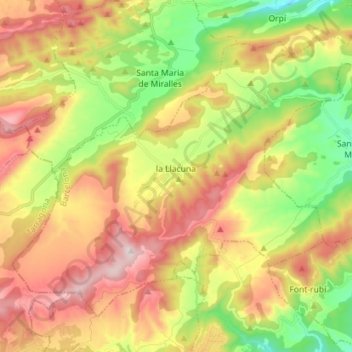
Name: la Llacuna topographic map, elevation, terrain.
Location: la Llacuna, Anoia, Barcelona, Catalonia, 08779, Spain (41.42808 1.46848 41.51325 1.61053)
Average elevation: 639 m
Minimum elevation: 370 m
Maximum elevation: 937 m
Make a donation
Gear up for your next adventure:
As an Amazon Associate, this site earns from qualifying purchases at no extra cost to you.
Other topographic maps
Click on a map to view its topography, its elevation and its terrain.