Geolocate

Sector 18 topographic map

Click on the map to display elevation.

About this map

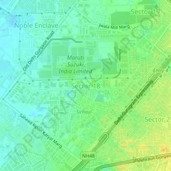
Name: Sector 18 topographic map, elevation, terrain.

Location: Sector 18, Gurgaon, Gurugram, Haryana, India (28.47911 77.05614 28.50369 77.08622)

Average elevation: 235 m

Minimum elevation: 224 m

Maximum elevation: 250 m

Gear up for your next adventure:

🐕Hiking Dog Pack - Let your canine companion carry their own water and food
🎒Backpack Rain Cover - External shield to keep your entire pack dry
💧Collapsible Water Bottle - Space-saving water bottle for outdoor activities
🧴Waterproofing Spray - Restore the DWR coating on jackets and tents
🩹Compact First Aid Kit - Pre-packed essentials for common trail injuries

As an Amazon Associate, this site earns from qualifying purchases at no extra cost to you.