Geolocate

Yauri topographic map

Interactive map

Click on the map to display elevation.

About this map

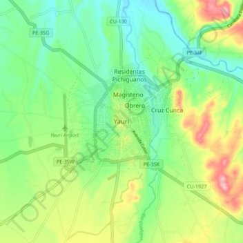
Name: Yauri topographic map, elevation, terrain.

Location: Yauri, Espinar, Cusco, 08301, Peru (-14.83301 -71.45280 -14.75301 -71.37280)

Average elevation: 3,907 m

Minimum elevation: 3,857 m

Maximum elevation: 3,996 m

Die auf einer Höhe von 3976 m im Andenhochland gelegene Stadt befindet sich 150 km südsüdöstlich der Regionshauptstadt Cusco, 170 km westnordwestlich vom Nordufer des Titicacasees sowie 680 km ostsüdöstlich der Landeshauptstadt Lima. Der Oberlauf des Río Apurímac verläuft 8 km westlich der Stadt in nördlicher Richtung. Knapp 15 km südöstlich der Stadt befindet sich die Kupfermine Tintaya.

Wikipedia (CC-BY-SA 3.0)