Geolocate

Omiš topographic map

Click on the map to display elevation.

About this map

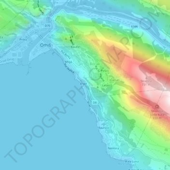
Name: Omiš topographic map, elevation, terrain.

Location: Omiš, Grad Omiš, Split-Dalmatia County, 21310, Croatia (43.41903 16.67728 43.45085 16.72699)

Average elevation: 142 m

Minimum elevation: -13 m

Maximum elevation: 783 m

Gear up for your next adventure:

🥾Mountaineering Boots - Supportive boots for climbing and high-altitude hiking
🧥Waterproof Hiking Jacket - Protect yourself from rain and wind while hiking
💧Hydration Bladder - Hands-free hydration solution for long treks
🧶550 Survival Paracord - Versatile utility cord for emergency repairs and rigging
🧭GPS Tracker - Track your location in remote areas safely

As an Amazon Associate, this site earns from qualifying purchases at no extra cost to you.