
Make a donation
Gear up for your next adventure:
As an Amazon Associate, this site earns from qualifying purchases at no extra cost to you.
Chantilly topographic map
Click on the map to display elevation.
Make a donation
Gear up for your next adventure:
As an Amazon Associate, this site earns from qualifying purchases at no extra cost to you.
Chantilly
Chantilly straddles the junction of the Paris Basin and the western County of Valois, of which the Nonette River is a boundary. The site of the town was originally a clearing or meadowland, sometimes called a lawn or pelouse, which is mostly occupied today by the racecourse. The remaining open space between the town and the racecourse is always referred to as the "little lawn". The highest point in the area, 112 meters, is at Bois Lorris, in Lamorlaye. The lowest elevation is 35m, at the Canardière on the banks of the Nonette in Gouvieux.
Make a donation
Gear up for your next adventure:
As an Amazon Associate, this site earns from qualifying purchases at no extra cost to you.
About this map
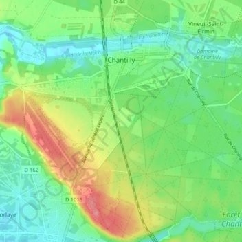
Name: Chantilly topographic map, elevation, terrain.
Average elevation: 61 m
Minimum elevation: 31 m
Maximum elevation: 116 m
Make a donation
Gear up for your next adventure:
As an Amazon Associate, this site earns from qualifying purchases at no extra cost to you.
Other topographic maps
Click on a map to view its topography, its elevation and its terrain.