Geolocate

Ourense topographic map

Click on the map to display elevation.

About this map
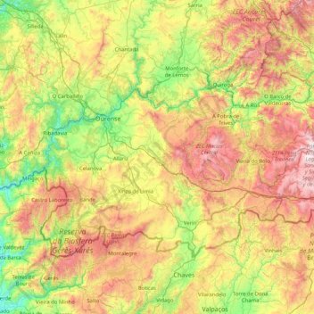
Name: Ourense topographic map, elevation, terrain.

Location: Ourense, Galicia, Spain (41.80736 -8.36634 42.57860 -6.73395)

Average elevation: 750 m

Minimum elevation: 42 m

Maximum elevation: 2,088 m

Gear up for your next adventure:

⛺Lightweight Camping Tent - Portable shelter optimized for Canadian backcountry camping
🧭Orienteering Kit - Tools for map reading and navigation in the wild
👟Trail Running Shoes - Agile footwear for fast-paced topographic exploration
🔦UV Flashlight - Detect minerals or specific insects in the dark
🔦LED Headlamp - Hands-free lighting for early morning starts or late finishes

As an Amazon Associate, this site earns from qualifying purchases at no extra cost to you.