Geolocate

Mount Cooroora topographic map

Click on the map to display elevation.

About this map

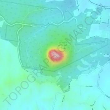
Name: Mount Cooroora topographic map, elevation, terrain.

Location: Mount Cooroora, Pomona, Noosa Shire, Queensland, Australia (-26.37144 152.83801 -26.37134 152.83811)

Average elevation: 140 m

Minimum elevation: 84 m

Maximum elevation: 401 m

Other topographic maps

Click on a map to view its topography, its elevation and its terrain.

Pomona

Australia > Queensland > Pomona

Average elevation: 114 m

Tuchekoi National Park

Australia > Queensland > Pomona

Average elevation: 119 m

Pinbarren Creek

Australia > Queensland > Pomona

Average elevation: 118 m

Gear up for your next adventure:

🥘Camping Cookware Set - Compact nesting pots and pans for trail cooking
🥾Trail Hiking Shoes - Durable shoes designed for rugged trails
👟Sport Hiking Sandals - Breathable footwear for water crossings and camp rest
🗺️Topographic Maps - Detailed maps to explore trails, mountains, and wilderness areas
🧦Thermal Socks - Warm socks for winter hiking or camping

As an Amazon Associate, this site earns from qualifying purchases at no extra cost to you.