Geolocate

Kojori topographic map

Click on the map to display elevation.

About this map

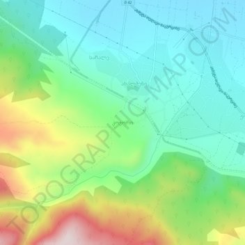
Name: Kojori topographic map, elevation, terrain.

Location: Kojori, Akhmeta Municipality, Kakheti, Georgia (41.97180 45.23902 42.01180 45.27902)

Average elevation: 659 m

Minimum elevation: 491 m

Maximum elevation: 1,033 m

Other topographic maps

Click on a map to view its topography, its elevation and its terrain.

Gear up for your next adventure:

🧭GPS Tracker - Track your location in remote areas safely
🧤Insulated Winter Gloves - Heavy-duty protection for sub-zero Canadian adventures
🎒Backpack Rain Cover - External shield to keep your entire pack dry
👟Leg Gaiters - Keep debris, mud, and snow out of your boots
🧊Portable Cooler - Keep food and drinks cold during outdoor adventures

As an Amazon Associate, this site earns from qualifying purchases at no extra cost to you.