Geolocate

Martinique topographic map

Click on the map to display elevation.

About this map

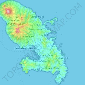
Name: Martinique topographic map, elevation, terrain.

Location: Martinique, France (14.38867 -61.22920 14.87873 -60.80958)

Average elevation: 67 m

Minimum elevation: -1 m

Maximum elevation: 1,370 m

Other topographic maps

Click on a map to view its topography, its elevation and its terrain.

Baie de Fort-de-France

France > Martinique

Average elevation: 0 m

Canton Suisse

France > Martinique > Le Morne-Vert

Average elevation: 337 m

Le Diaka

France > Martinique > Le Marin

Average elevation: 38 m

Gear up for your next adventure:

🦶Hiking Shoe Insoles - Added support for high arches and long days on feet
Family Camping Tent - Spacious tent suitable for family camping trips
🧥Waterproof Pants - Keep dry during rainy hiking conditions
🪑Insulated Seat Pad - Protect your seat from cold rocks and wet logs
🧢Hiking Hat - Sun-protective and breathable hats for long treks

As an Amazon Associate, this site earns from qualifying purchases at no extra cost to you.