Geolocate

Aurora topographic map

Click on the map to display elevation.

About this map
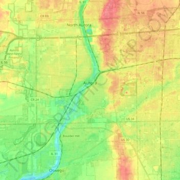
Name: Aurora topographic map, elevation, terrain.

Location: Aurora, Aurora Township, Kane County, Illinois, United States (41.67987 -88.40837 41.82218 -88.20499)

Average elevation: 212 m

Minimum elevation: 183 m

Maximum elevation: 241 m

Other topographic maps

Click on a map to view its topography, its elevation and its terrain.
Elgin

United States > Illinois > Kane County

Average elevation: 255 m

Elgin

United States > Illinois > Kane County

Average elevation: 255 m

Campton Township

United States > Illinois > Kane County

Average elevation: 267 m

Gear up for your next adventure:

🥾Approach Shoes - Shoes designed for climbing approaches and rugged trails
🛶Kayak Accessories - Essential gear for safe and fun kayaking adventures
🧴Outdoor Sunscreen - High SPF protection for high-altitude UV exposure
🥾Hiking Leggings - Comfortable leggings for outdoor activities
🧭Orienteering Kit - Tools for map reading and navigation in the wild

As an Amazon Associate, this site earns from qualifying purchases at no extra cost to you.