Geolocate

Amorbach topographic map

Click on the map to display elevation.

About this map

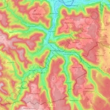
Name: Amorbach topographic map, elevation, terrain.

Location: Amorbach, Landkreis Miltenberg, Bavaria, 63916, Germany (49.57875 9.08796 49.69697 9.30650)

Average elevation: 353 m

Minimum elevation: 123 m

Maximum elevation: 538 m

Gear up for your next adventure:

🧭GPS Tracker - Track your location in remote areas safely
🧥Packable Rain Jacket - Breathable waterproof layer for unpredictable weather
🥾Trekking Boots - Durable boots for long-distance trekking
🧣Merino Neck Gaiter - Protects against wind, sun, and cold at high altitudes
🥾Durable Hiking Shoes - Long-lasting shoes for frequent hiking

As an Amazon Associate, this site earns from qualifying purchases at no extra cost to you.