Geolocate

Gestratz topographic map

Click on the map to display elevation.

About this map

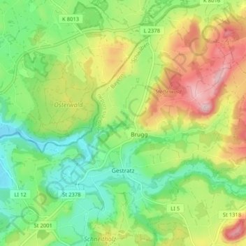
Name: Gestratz topographic map, elevation, terrain.

Location: Gestratz, Argental (VGem), Landkreis Lindau, Bavaria, Germany (47.63160 9.96334 47.68497 10.03116)

Average elevation: 698 m

Minimum elevation: 600 m

Maximum elevation: 848 m

Gear up for your next adventure:

💡LED Camping Lantern - Illuminate your campsite with long-lasting lanterns
🧥Waterproof Jacket - Lightweight rain jackets for hiking and outdoor activities
🍽️Titanium Camping Spork - Ultralight and indestructible eating utensil
🌡️Emergency Mylar Blankets - Compact thermal protection for unexpected nights outdoors
🥾Trekking Poles - Adjustable trekking poles to reduce knee stress and improve stability

As an Amazon Associate, this site earns from qualifying purchases at no extra cost to you.