Geolocate

Hamilton topographic map

Click on the map to display elevation.

About this map

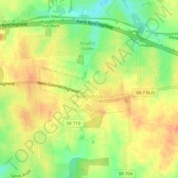
Name: Hamilton topographic map, elevation, terrain.

Location: Hamilton, Loudoun County, Virginia, 20159, United States (39.13170 -77.67223 39.13900 -77.65468)

Average elevation: 152 m

Minimum elevation: 125 m

Maximum elevation: 171 m

Gear up for your next adventure:

🔥Emergency Fire Starter - Reliable ignition source for all weather conditions
🥾Hiking Leggings - Comfortable leggings for outdoor activities
🥾Hiking Boots - Sturdy boots providing ankle support and traction on rugged trails
🚲Heavy Duty Bike Lock - Secure your bike at the trailhead or during stops
🧭Orienteering Kit - Tools for map reading and navigation in the wild

As an Amazon Associate, this site earns from qualifying purchases at no extra cost to you.