Geolocate

Pekanbaru topographic map

Click on the map to display elevation.

About this map

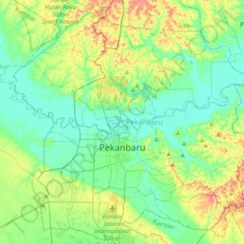
Name: Pekanbaru topographic map, elevation, terrain.

Location: Pekanbaru, Riau, Sumatra, Indonesia (0.41698 101.32606 0.69242 101.59288)

Average elevation: 24 m

Minimum elevation: -1 m

Maximum elevation: 81 m

Other topographic maps

Click on a map to view its topography, its elevation and its terrain.

Pangkalan Kerinci Kota

Indonesia > Riau > Pelalawan

Average elevation: 11 m

Pangkalan Kerinci

Indonesia > Riau > Pelalawan

Average elevation: 14 m

Bengkalis

Indonesia > Riau > Bengkalis Regency

Average elevation: 3 m

Pekanbaru

Indonesia > Riau > Kampar Regency

Average elevation: 22 m

Gear up for your next adventure:

🧤Rechargeable Heated Gloves - Extreme warmth for Canadian winter expeditions
🔦UV Flashlight - Detect minerals or specific insects in the dark
🥾Hiking Shorts - Breathable shorts suitable for summer hikes
🧦Hiking Liner Socks - Thin base layer to prevent friction and blisters
🧦Hiking Socks - Moisture-wicking and comfortable socks for long hikes

As an Amazon Associate, this site earns from qualifying purchases at no extra cost to you.