Geolocate

Luleå topographic map

Click on the map to display elevation.

About this map

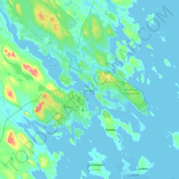
Name: Luleå topographic map, elevation, terrain.

Location: Luleå, Luleå kommun, Norrbotten County, 971 28, Sweden (65.42312 21.98595 65.74312 22.30595)

Average elevation: 11 m

Minimum elevation: -3 m

Maximum elevation: 139 m

Other topographic maps

Click on a map to view its topography, its elevation and its terrain.

Pajala kommun

Sweden > Norrbotten County

Average elevation: 262 m

Gear up for your next adventure:

🔦LED Flashlight - Powerful and long-lasting flashlight for camping and emergencies
🥾Approach Boots - Comfortable boots for hiking and climbing approaches
🩹Compact First Aid Kit - Pre-packed essentials for common trail injuries
🧭GPS Handheld Device - Reliable GPS navigation for outdoor adventures
🧶550 Survival Paracord - Versatile utility cord for emergency repairs and rigging

As an Amazon Associate, this site earns from qualifying purchases at no extra cost to you.