
Fayetteville topographic map
Interactive map
Click on the map to display elevation.
About this map
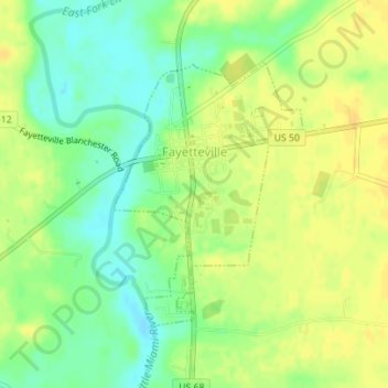
Name: Fayetteville topographic map, elevation, terrain.
Location: Fayetteville, Brown County, Ohio, United States (39.17458 -83.93937 39.19297 -83.92235)
Average elevation: 286 m
Minimum elevation: 271 m
Maximum elevation: 296 m
Other topographic maps
Click on a map to view its topography, its elevation and its terrain.
Chasetown
United States > Ohio > Brown County
Chasetown, Brown County, Ohio, 45118, United States
Average elevation: 288 m