Geolocate

Overbrook topographic map

Click on the map to display elevation.

About this map

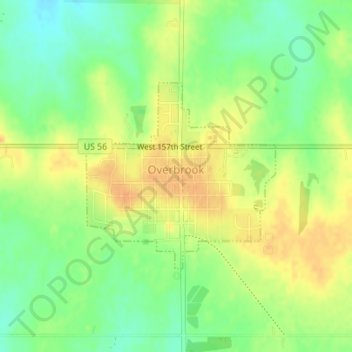
Name: Overbrook topographic map, elevation, terrain.

Location: Overbrook, Osage County, Kansas, United States (38.77293 -95.56604 38.78721 -95.54739)

Average elevation: 357 m

Minimum elevation: 339 m

Maximum elevation: 373 m

Gear up for your next adventure:

Camping Groundsheet - Protect your tent from moisture and dirt
💧Hydration Bladder - Hands-free hydration solution for long treks
🕶️Polarized Sunglasses - Reduces glare from snow and water at high elevations
🪜Heavy Duty Carabiners - Multi-use clips for securing gear to your backpack
🥾Trail Running Shoes - Lightweight and durable shoes for trail running

As an Amazon Associate, this site earns from qualifying purchases at no extra cost to you.