Geolocate

Canelli topographic map

Click on the map to display elevation.

About this map

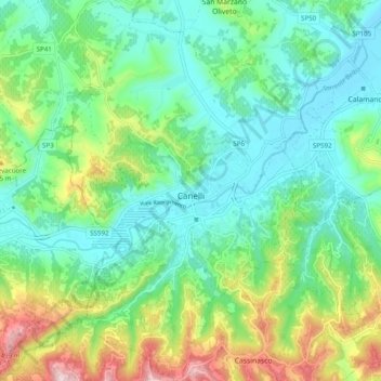
Name: Canelli topographic map, elevation, terrain.

Location: Canelli, Asti, Piedmont, 14053, Italy (44.68522 8.25491 44.75507 8.31700)

Average elevation: 248 m

Minimum elevation: 140 m

Maximum elevation: 519 m

Other topographic maps

Click on a map to view its topography, its elevation and its terrain.

Zolfo

Italy > Piedmont > Asti > Montafia

Average elevation: 226 m

Gear up for your next adventure:

🧴Waterproofing Spray - Restore the DWR coating on jackets and tents
🥾Waterproof Hiking Boots - Boots keeping your feet dry in wet conditions
🧢Sun Protection Cap - Breathable cap to protect from sun exposure
🧰Emergency Multi-Tool - Compact multi-tool for outdoor survival
Camping Groundsheet - Protect your tent from moisture and dirt

As an Amazon Associate, this site earns from qualifying purchases at no extra cost to you.