Geolocate

Pettendorf topographic map

Click on the map to display elevation.

About this map

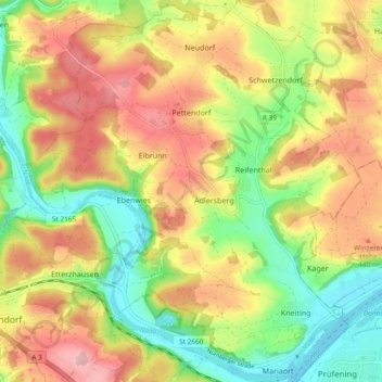
Name: Pettendorf topographic map, elevation, terrain.

Location: Pettendorf, Landkreis Regensburg, Bavaria, 93186, Germany (49.01493 11.96458 49.07629 12.04794)

Average elevation: 406 m

Minimum elevation: 329 m

Maximum elevation: 487 m

Other topographic maps

Click on a map to view its topography, its elevation and its terrain.

Eggmühl

Germany > Bavaria > Landkreis Regensburg

Average elevation: 382 m

Langenerling

Germany > Bavaria > Landkreis Regensburg

Average elevation: 355 m

Wahlsdorf

Germany > Bavaria > Landkreis Regensburg

Average elevation: 435 m

Gear up for your next adventure:

🦶Hiking Shoe Insoles - Added support for high arches and long days on feet
🪑Insulated Seat Pad - Protect your seat from cold rocks and wet logs
🛌Insulated Sleeping Pad - Critical thermal barrier between you and the cold ground
🧥Thermal Layer - Insulating layer for cold outdoor conditions
🧥Waterproof Pants - Keep dry during rainy hiking conditions

As an Amazon Associate, this site earns from qualifying purchases at no extra cost to you.