
Make a donation
Gear up for your next adventure:
As an Amazon Associate, this site earns from qualifying purchases at no extra cost to you.
Grad Požega topographic map
Click on the map to display elevation.
Make a donation
Gear up for your next adventure:
As an Amazon Associate, this site earns from qualifying purchases at no extra cost to you.
Grad Požega
Požega (elevation: 152 m (499 ft)) is located in the south-western part of the Valley of Požega, or Požega basin, in Croatian: Požeška kotlina. This fertile valley has been important since the antiquity - its Roman name was Vallis Aurea, meaning "golden valley".
Make a donation
Gear up for your next adventure:
As an Amazon Associate, this site earns from qualifying purchases at no extra cost to you.
About this map
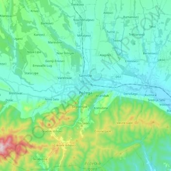
Name: Grad Požega topographic map, elevation, terrain.
Location: Grad Požega, Požega-Slavonia County, 34000, Croatia (45.26777 17.56777 45.40587 17.75298)
Average elevation: 222 m
Minimum elevation: 127 m
Maximum elevation: 595 m
Make a donation
Gear up for your next adventure:
As an Amazon Associate, this site earns from qualifying purchases at no extra cost to you.