

Mount Elbert topographic map
Click on the map to display elevation.
Mount Elbert
Mount Elbert is the highest summit of the Rocky Mountains of North America. With an elevation of 14,438 feet (4400.58 m), it is also the highest point in the U.S. state of Colorado and the second-highest summit in the contiguous United States after Mount Whitney, which is slightly taller. The ultra-prominent fourteener is the highest peak in the Sawatch Range, as well as the highest point in the entire Mississippi River drainage basin. Mount Elbert is located in San Isabel National Forest, 12.1 miles (19.4 km) southwest (bearing 223°) of the city of Leadville in Lake County, Colorado.
About this map
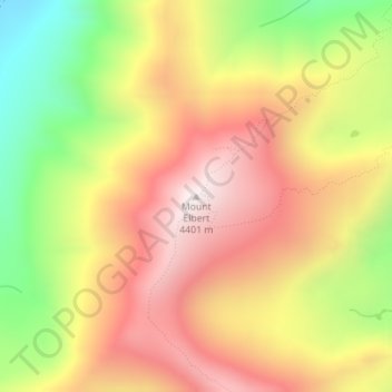
Name: Mount Elbert topographic map, elevation, terrain.
Location: Mount Elbert, Lake County, Colorado, United States (39.11770 -106.44543 39.11780 -106.44533)
Average elevation: 3,959 m
Minimum elevation: 3,422 m
Maximum elevation: 4,394 m
Other topographic maps
Click on a map to view its topography, its elevation and its terrain.
Leadville
United States > Colorado > Lake County
The City of Leadville is a statutory city that is the county seat, the most populous community, and the only incorporated municipality in Lake County, Colorado, United States. The city population was 2,602 at the 2010 census and an estimated 2,762 in 2018. It is situated at an elevation of 10,152 feet (3,094…
Average elevation: 3,107 m
Mount Massive Wilderness
United States > Colorado > Lake County
The Mount Massive Wilderness is a federally designated wilderness area in the Sawatch Range, located in the U.S. state of Colorado. It is operated jointly by the United States Forest Service and the Fish and Wildlife Service as part of the San Isabel National Forest and the Leadville National Fish Hatchery. It…
Average elevation: 3,432 m
Leadville
United States > Colorado > Lake County
Leadville (/ˈlɛdvɪl/ LED-vil) is a statutory city that is the county seat of, the most populous community in, and the only incorporated municipality in Lake County, Colorado, United States. The city population was 2,633 at the 2020 United States census. It is situated at an elevation of 10,119 feet (3,084…
Average elevation: 3,107 m
Leadville
United States > Colorado > Lake County
The City of Leadville is a statutory city that is the county seat, the most populous community, and the only incorporated municipality in Lake County, Colorado, United States. The city population was 2,602 at the 2010 census and an estimated 2,762 in 2018. It is situated at an elevation of 10,152 feet (3,094…
Average elevation: 3,107 m